
Sea ice forms on the ocean surface and is a critical part of the polar ice landscape. Its floating white reflective surface serves various functions in both the ecosystem and the climate system. Sea ice varies seasonally. In Antarctica, the largest concentration is found in September, at the end of the austral winter, and then begins to reduce as the weather warms until it reaches its minimum in late February before colder temperatures return. Sea ice also varies regionally, and in Antarctica the area around Thwaites glacier has seen sea ice decline for the three decades prior to 2010. More recently the trend is less clear.
frozen ocean water
Southern Hemisphere
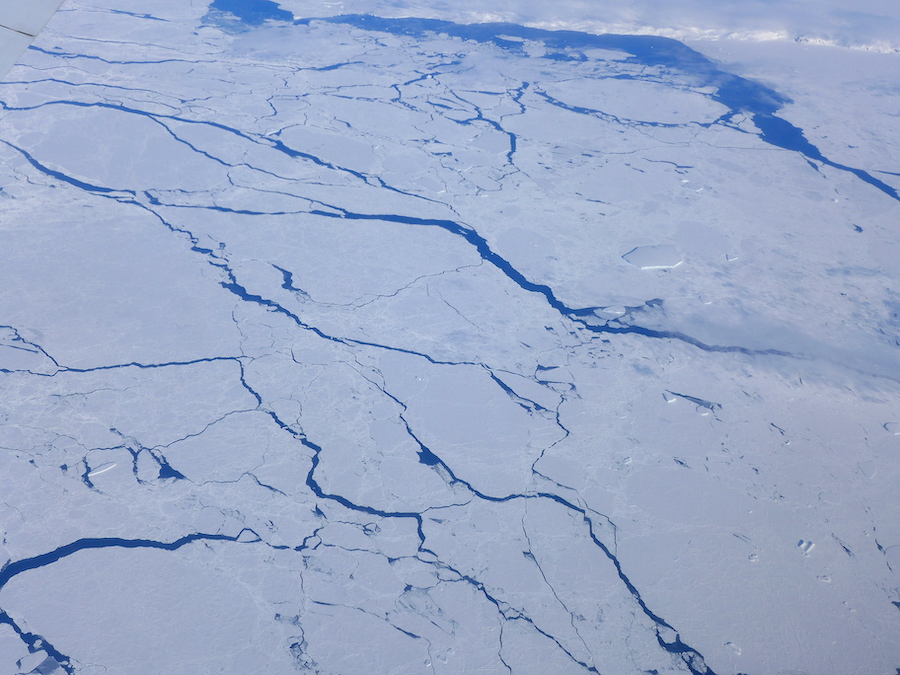
Photo of Antarctic sea ice Amundsen Sea 2016. (Image credit: M. Turrin )
What is Sea Ice? Sea ice is frozen ocean water that forms in the polar regions when air and water temperatures are cold enough to freeze the ocean surface. Because ice is less dense than water, sea ice floats, forming a reflective white platform on the ocean surface. Sea ice thickness varies, but in general Arctic sea ice is a combination of annual and multi-year ice with an average thickness of 2 to 3 meters (6-9 ft), while Antarctic sea ice is primarily annual (single year) ice with on average thickness of 1 to 2 meters (3-6 ft). As the ocean water freezes it forces out the salt which then sinks creating denser water below. This denser water becomes an important driver of ocean circulation. Antarctic sea ice plays critical roles in ocean ecology and global climate.
Photo of Antarctic krill (Euphausia superba) (Image credit: Creative Commons ).jpg)
What role does sea ice play in ecology? The floating sea ice platform is the base of the Antarctic food web with links to two key 'primary producers'; sea ice algae that grows on the underside of the ice, and other phytoplankton that often resides under the ice where it is carried by currents. Antarctic krill (photo), an open-ocean crustacean that consumes both the sea ice algae and phytoplankton, supports a large portion of the marine ecosystem food web including fish, penguin, seal and whale. While Antarctic krill is considered one of the most abundant animal species on Earth and a critical piece of the marine ecosystem, it has been in decline, dropping by 80% since 1975 according to researchers. Several other Antarctic species are also dependent on sea ice. Antarctic seal species, like the Crabeater, Weddell, Ross, Leopard, rely on sea ice for both foraging and reproduction, while Adélie penguin both live on or close to sea ice and forage krill as a main part of their diet.
the autotrophic (self-feeding) components of the plankton community and a key part of aquatic ecosystems
Fractional ice cover, Antarctic sea ice 1979-2012. (Image credit: J. King, 2014, Nature)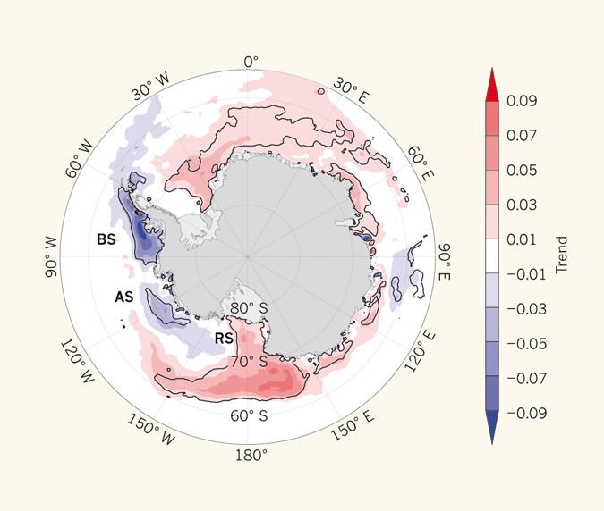
What role does sea ice play in global climate? Antarctic sea ice contributes to global climate in several ways. Albedo: The expansive white floating sea ice platform is reflective sending an estimate 80% of the heat energy that comes down from the sun back into space. This not only keeps the polar regions cool but also helps modulate global climate. Scientists measure the reflective quality of things on something called an albedo scale. Ranging from 0-1 (fully absorptive to fully reflective) sea ice ranks on the high end of the scale at 0.8, but if the sea ice becomes snow covered its reflectivity increases to 0.9 returning even more heat energy to space. Antarctic sea ice is often snow covered since it is surrounded by the Southern Ocean feeding a cycle of precipitation. Circulation: One main driver of ocean circulation is the density differences that result from the formation of sea ice. At both poles, as the ocean surface freezes it ejects the salt crystals which creates a heavy dense layer that sinks in the ocean. This cold dense water from polar regions moves along the bottom of the ocean towards the equator while over top of it warmer less salty water travels from the equator towards the polar regions driving the 'ocean conveyor belt' (a term for the full ocean circulation system.) Buffer: Sea ice also serves as a buffer protecting the ice shelf from storms, wind and waves that can erode the ice shelf edge causing it to weaken. The ice shelves, in turn, protect glaciers and the ice sheet from ocean interaction and help to stabilize the land ice behind them.
large scale movement of waters in the ocean basins
proportion of the incident light or radiation reflected by a surface
something designed to prevent things from coming into contact and harming each other
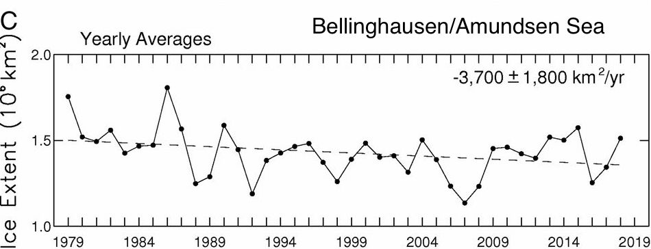
40 years of sea ice extent in the Amundsen Sea. (Image credit: Edited from Parkinson, 2019 PNAS )
What's happening with Antarctic sea ice? The map image above shows Antarctic sea ice trends from 1979-2012 as a change in the fractional sea ice cover (or concentration) for a given area. You can see that sea ice in the peninsula and around Thwaites glacier region has been on the decline over this time period while much of the rest of Antarctica has seen a rise in annual sea ice. Black lines outline areas that show a statistically significant change over the time period. Recently published data from 2019 suggest that overall sea ice around Antarctica peaked in 2014 and suffered a large decline by 2017. However, throughout the full time period the Thwaites/Amundsen Sea region has shown a different pattern than the rest of Antarctica. While the earlier decades showed significant decline in this area, recent satellite data has showed sea ice in this region has been increasing, although still falling below historic concentrations. The drop in sea ice around the Thwaites glacier has exposed the ice shelf to warming ocean water causing it to weaken.
What can we learn from the app? Click through the app and watch Antarctic sea ice grow during the Antarctic (Austral) winter and decline in the warmer summer season. Recall what is happening to the sun during the winter in Antarctica. What role do you think this might have on sea ice growth? Carefully watch the ice in the austral summer. What affect do you think this will have on Thwaites glacier?
How was this data collected? The data for these maps are collected from satellites using passive microwave radiometers. The maps represent sea ice 'concentration' and require a minimum 15% concentration value in a location in order to be included. Scientists also map sea ice based on 'extent' which means how far it reaches out into the ocean. The maps represent a monthly average. Although changes in any given month can be highly variable, monthly averages provide reliable and important seasonal information.
sensitive receivers designed to measure thermal energy being emitted
Data Source
Sea Ice Version 3 Analysis, NSIDC
Additional information/References
A 40-y record reveals gradual Antarctic sea ice increases followed by decreases at rates far exceeding the rates seen in the Arctic
Sea Ice
A resolution of the Antarctic paradox
World of Change: Antarctic Sea Ice